An 1840 “Casier Geographique” (Geographical Locker): A New Acquisition at the Cushing Memorial Library and Archives
By Sierra Laddusaw | 03-01-2021
As curator of the Map Collection, the majority of items I acquire for the collection are flat sheets of paper. Single-sheet maps or a collection of several sheets, occasionally an atlas: it is rare that an object like this locker becomes available that fits the collecting area. Recently, I was able to add a curious and beautiful cartographic object to the collection: Adrien-Hubert Brué and Charles Picquet’s Casier Geographique, simply translated to a Geographical Locker.
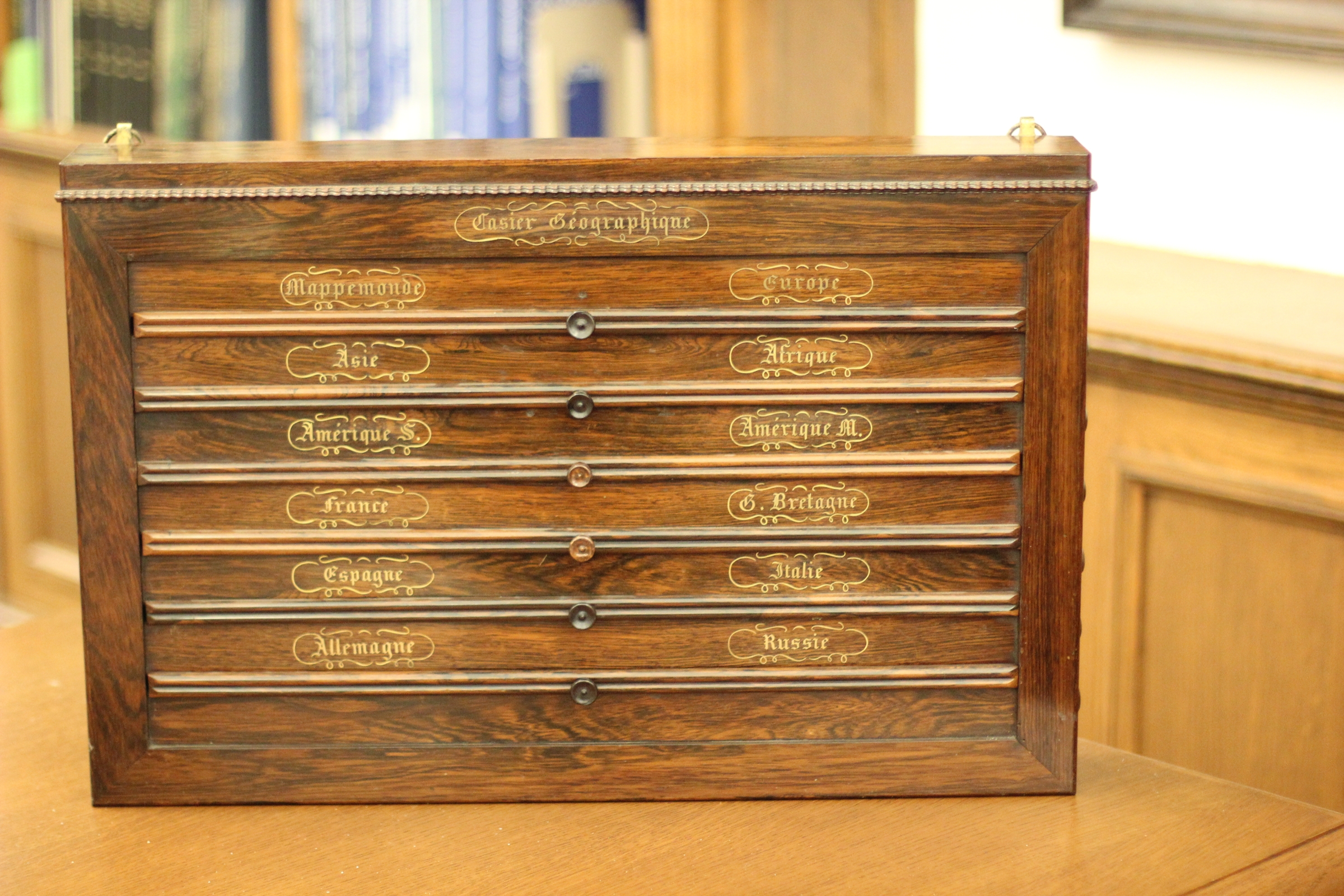
Our locker dates from approximately 1840. The cabinet is crafted from Brazillian rosewood and each map drawer features a label in gold-gilt script. The map drawers pull out to reveal maps, mounted on linen, and each drawer’s sheet includes two maps (for a total of 12 maps) printed from Brué’s atlas plates. The maps are hand-colored and range in date from 1827–1840. The drawers wind and unwind by means of a spring mechanism that can be controlled by knobs along the right side of the case. Unsurprisingly, with the case being over 180 years old, the mechanisms do not function as smoothly as they probably once did. However, all 6 sheets can be fully wound and unwound for use.
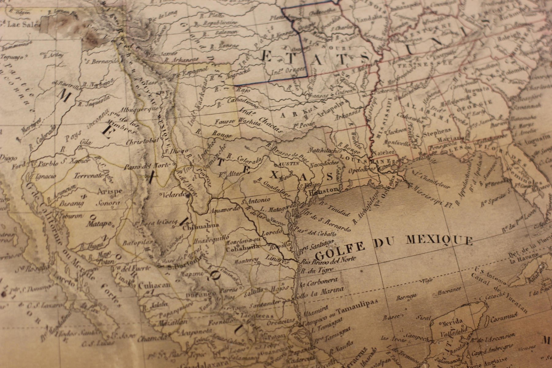
Excitingly, the map of North America features the Republic of Texas at its largest extent, the “stovepipe” formation. We are used to seeing the Texas panhandle end at the 36°30' parallel, however, on this map the tip of the extended Texas panhandle reaches all the way to the 42nd parallel, looking like the pipe of an antique stove, placing the Northernmost boundary of Texas in modern-day Wyoming! The North America map is the second Republic of Texas map from Brué in the Cushing collections. Brué famously drew the first international map that recognized Texas as an independent entity, during a time when both Spain and Mexico refused to recognize Texas independence and Great Britain was reluctant to. You can find this map, Carte Nouvelle du Mexique du Texas et d’une Partie des Etats Limitrophes, in the Floyd & Louise Chapman Texas & Borderlands Collection (Cushing Library/Texas Collection G4030 1840 .C7).
Brué was a French cartographer active in the late 18th and early 19th centuries. He served in the office of Geographe du Roi (King’s Geographer), where he created thousands of maps and atlases. These are easily identifiable, as Brué would sign the maps with his office title. Brué also held membership in the Société de Géographie de Paris and was a Friend of the Royal Geographical Society in London. Picquet and Brué regularly worked together on mapping projects. Outside of his work with Brué, Picquet is considered to have applied one of the earliest applications of spatial analysis in epidemiology, when mapping Cholera deaths in Paris. This famous Cholera map was published shortly after Brué died of Cholera in 1832. After Brué’s death, his partner continued to update and publish his maps. Picquet’s son, Pierre-Jacques Picquet, continued to publish both men’s maps posthumously.
Watch for the Casier Geographique and other maps from Cushing’s collection to appear in an upcoming Texas map exhibition, scheduled to open in Spring 2022.
Tags: Maps, Texas, Cartography, Adrien-Hubert Brué
Cushing Memorial Library and Archives Collections: Floyd & Louise Chapman Texas & Borderlands Collection
Contact Us: cushingcollective@library.tamu.edu
 |
Sierra Laddusaw is an Assistant Professor at the University Libraries. She is the Curator of Maps, Co-curator of the Chapman Texas & Borderlands Collection, Curator of Digital Scholarship, and Curator of the Maritime Collection at Cushing Memorial Library & Archives. Her research interests lie in mapping of ideas and imaginary places and the use of cartographic resources in non-traditional fields of study. She has curated a collection at the University Libraries of materials that blur the line between cartography and art. Sierra earned her Master of Library Science from Texas Woman’s University. |